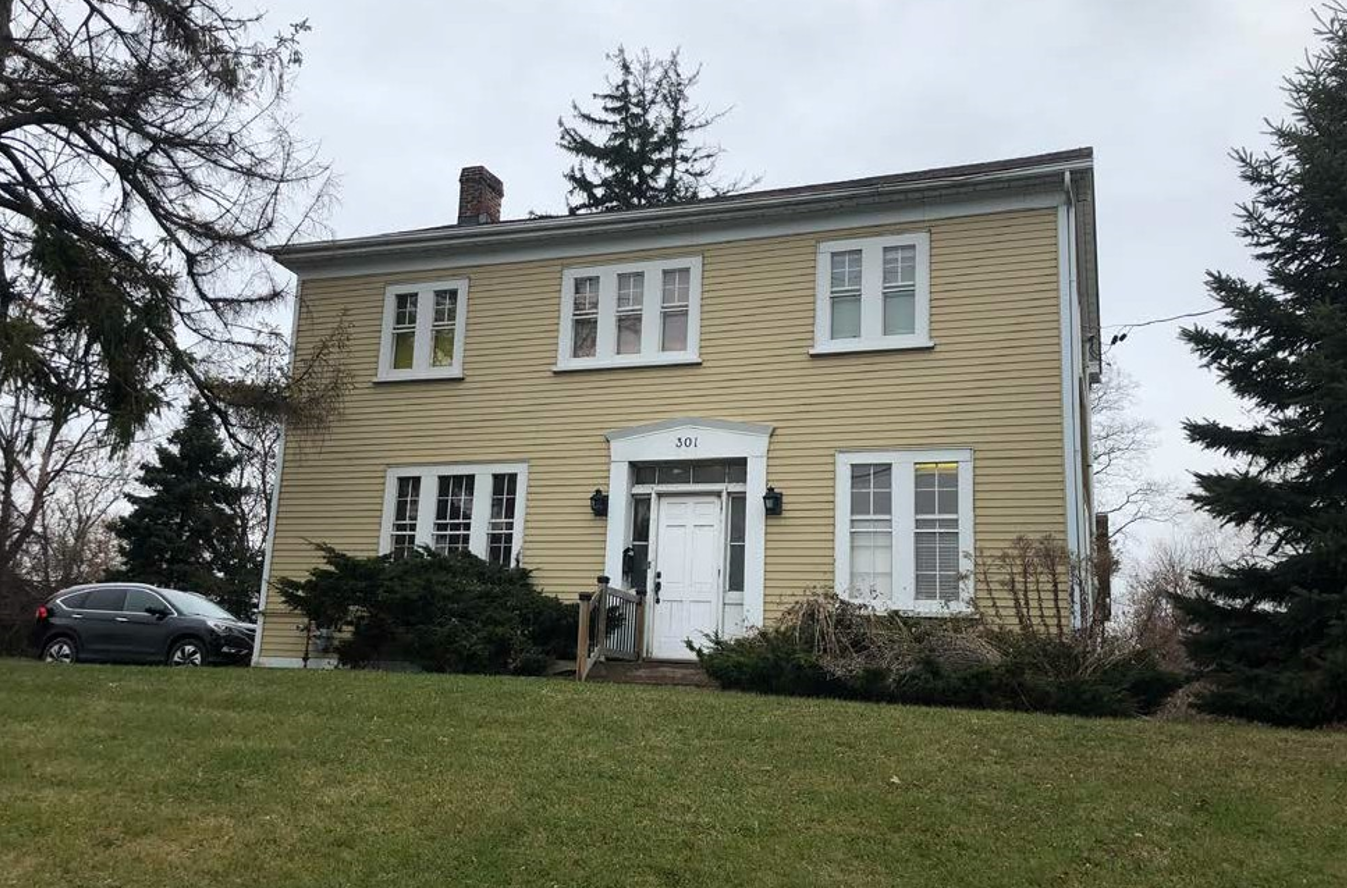
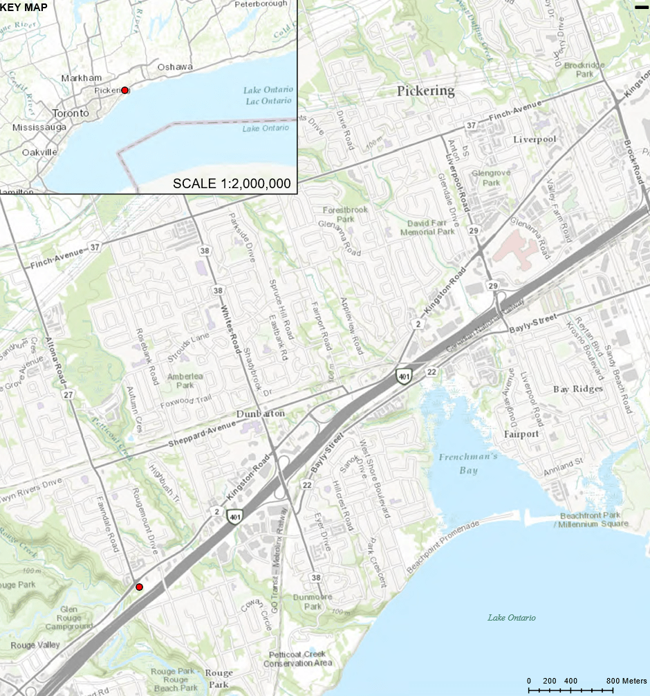
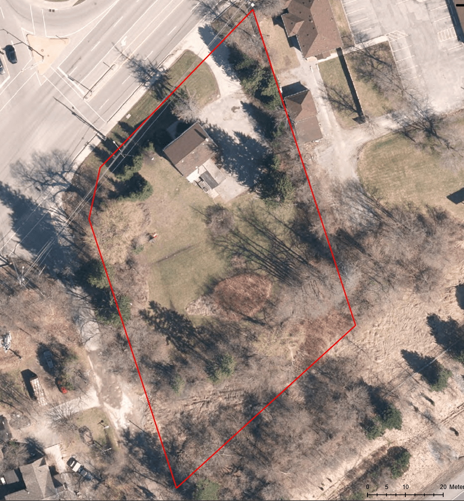
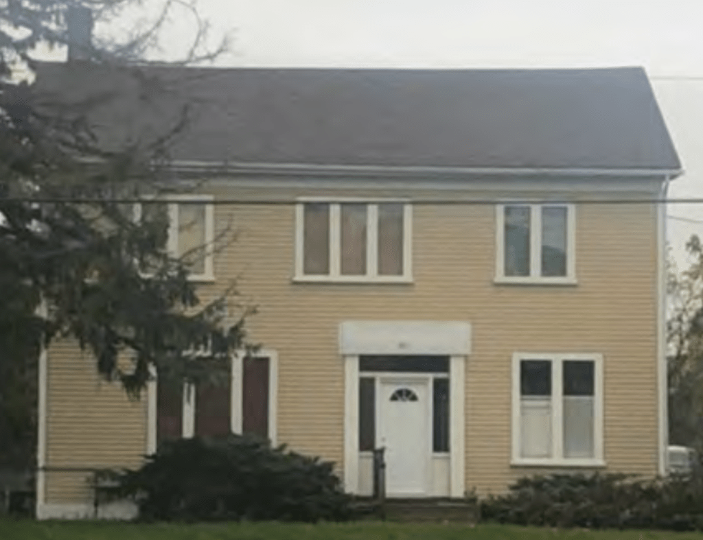
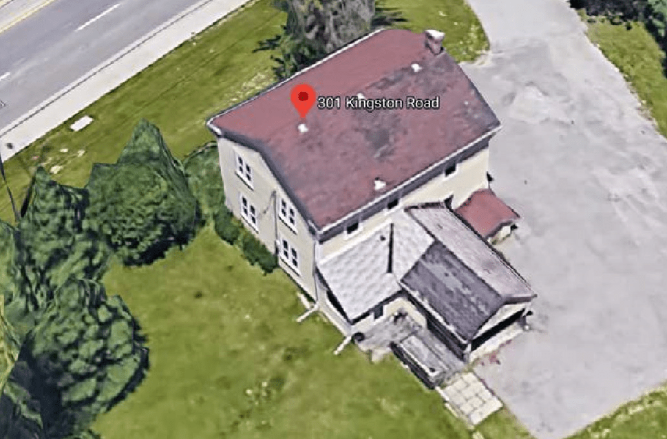
301 Kingston Rd
The Crown Patents for Lot 32, Concession 3 Broken Front was granted to prominent military surgeon William Holmes in 1798. Although Holmes never settled here, he was granted – and purchased- more than 1200 acres of land in Pickering Township. It was here that the community of Rouge hill developed along Kingston Road, overlooking the Rouge River Valley.
In this location once stood the two-storey, wood frame Georgian style residence of farmer John Charles Wesley, who farmed a 195-acre parcel of land stretching as far north as Sheppard Avenue. The house was constructed in the mid-19th century and sat in this prominent location at the corner of Kingston Road and Altona Road.
The Property
The Property is located in Peel Plain physiographic region. The Peel Plain is characterized by level-to-undulating clay soils, gently rolling topography which slopes westerly towards the Rouge River valley from the Property. The Credit, Humber, Don, and Rouge Rivers and streams such as the Bronte, Oakville, and Etobicoke Creeks have cut deep valleys across the plain. Soils in the area are predominantly imperfectly drained and stone-free clay loam.
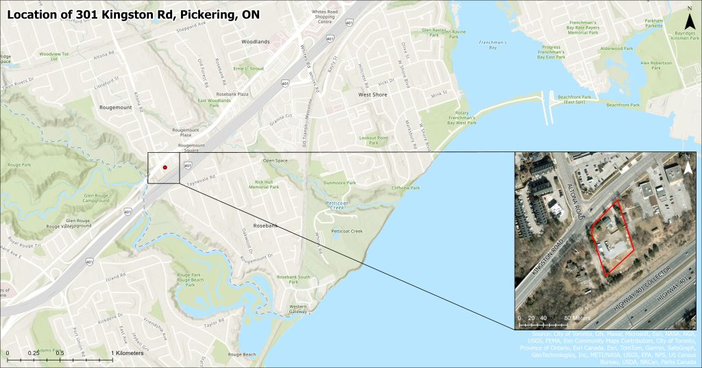
The Property is in the Rouge River watershed and the most prominent natural feature, the Rouge River, is found 300 metres to the west. The Rouge River travels in an east-west direction and is a tributary to Lake Ontario. The Rouge National Urban Park is also located to west and encompasses a large area that makes up Toronto’s only campground, the Toronto Zoo, the Greater Toronto Area’s last remaining working farms, and Carolinian ecosystems.107
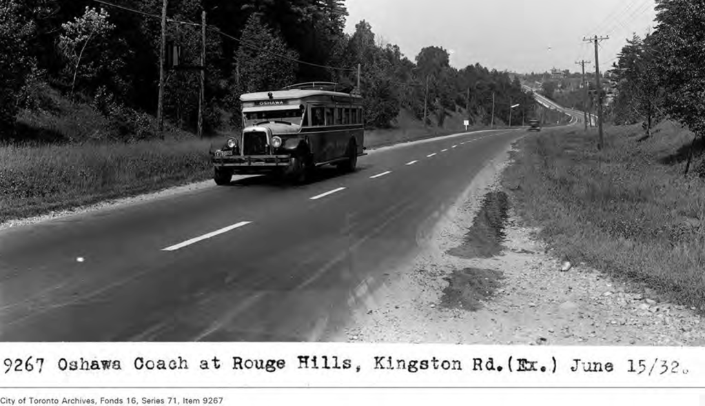
Kingston Road is a major four-lane road with the designation of Regional Road 2 which runs in a west-to-east direction. Kingston Road had much of the original road alignment altered during the early twentieth century.
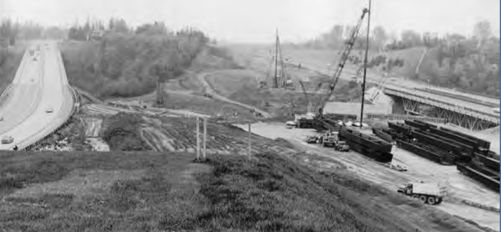
Altona Road is a four-lane road in a north-to-south direction. Altona Road has had much of the original road alignment altered with the construction of Highway 401 in the 1940s.
Background Research
301 Kingston Road is located within the Treaty and Traditional Territories of the Mississauga, the Scugog Island First Nation, and Williams Treaty signatories, the Mississauga and Chippewa Nations and the Huron Wendat. These lands have long been a home to many Indigenous peoples and we recognize our responsibility as stewards and caretakers of these lands and waters.
Kingston Road
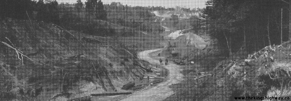
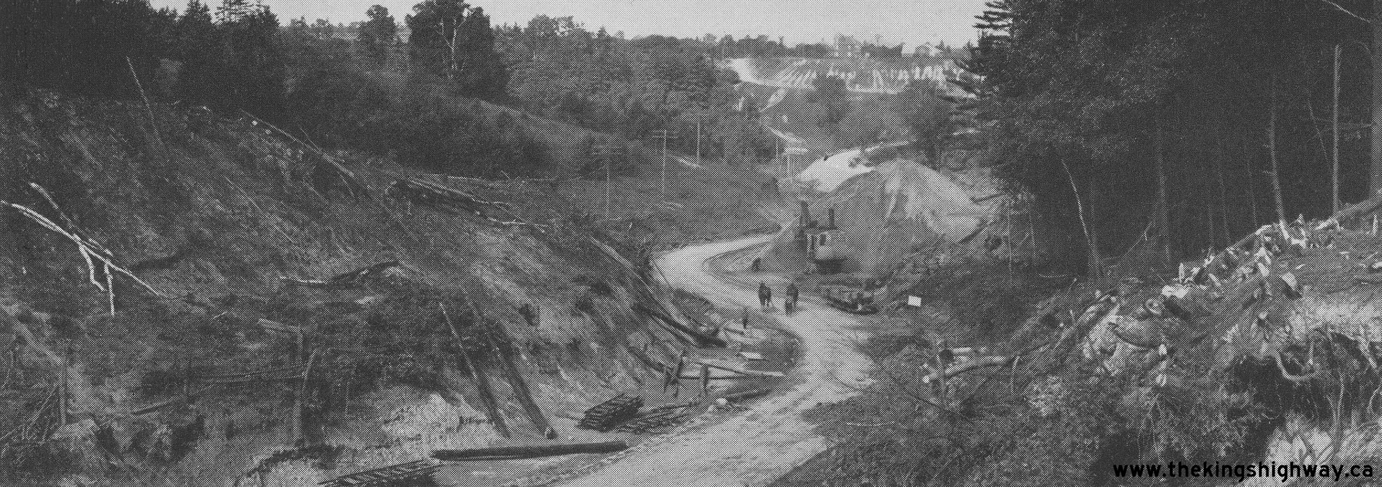
In 1796, following the survey and establishment of Yonge Street, the colonial administration intended to establish a road from the head of the lake (Hamilton) to Kingston, and engaged contractor Asa Danforth. In 1817, ongoing work on Kingston Road east of Scarborough was completed all the way through Kingston to Montréal. It was the first major land route for long distance transportation in Upper Canada. However, difficulty in maintaining Kingston Road limited its usefulness. The preferred mode of transportation for long distance travellers and shipping of goods was still by boat. By 1836, work was underway to “plank” Kingston Road from Toronto to Rouge Hill. This process involved securing 16-foot-wide planks of wood to cover the roadway and create a smoother surface. This improvement increased the popularity of Kingston Road as a travel route for coaches and sleds. Taverns and inns began to spring up along Kingston Road to accommodate the increasing number of travellers.51 Kingston Road was eventually converted to a gravel roadway and in 1898 the Toronto Railway Company began to operate a streetcar along Kingston Road. By 1905, the line was completed to West Hill and became the preferred mode of transportation along Kingston Road. In the 1920’s, Kingston Road was taken over by the Ontario Department of Public Highways and paved.52
Rouge Hill
The Property is located in the historic Rouge Hill area in the City of Pickering. Rouge Hill was initially associated with a dangerous crossing of the Rouge River in the Township of Pickering. In 1847, a new and safer plank and macadamized road and bridge were constructed over the Rouge River and a small cluster of homes were established in the hamlet.53 Due to the terrain of the Rouge Hill area, it was described as “highly picturesque, the river making many beautiful curves in its course, and forming islands which are studded with timber”.54 In the early days of stagecoaching along Kingston Road, the east hill above the Rouge River became a station point were horses were changed, and as such this location attained local prominence. A sawmill was constructed on the west bank of the Rouge River and by 1850, two hotels were constructed on the east bank, and operated by James Black and Andrew Noble. In 1852, Emanuel Playter became the first postmaster of Rouge Hill, having previously operated a general store.55 The 1859 British-American Guide Book noted the population of Rouge Hill as having 50 inhabitants.56
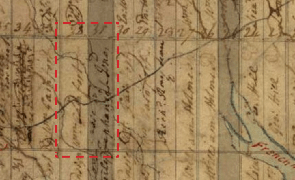
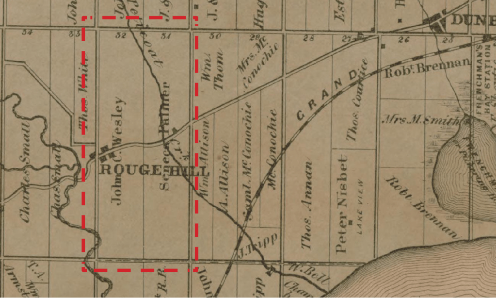
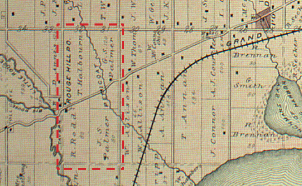
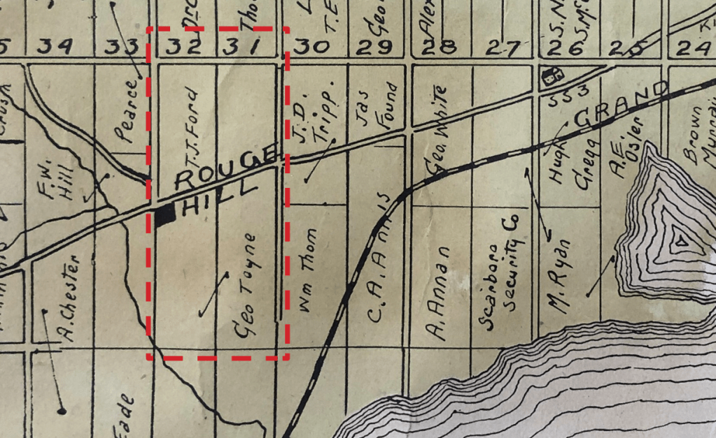
Rouge Hill is noted in the 1860 Tremaine’s Map of the County of York. This map also shows four structures along the intersection of Kingston Road between Lots 32 and 33, Concession 3. By 1870, a post office, saw mill, planning mill, woolen mill, steam carriage factory, cheese factory, cabinet factory, wagon shop, cooperage, shoemaker, and weaver, along with multiple other tradesmen were located in the hamlet.57 Conner & Coltson’s Directory of the County of Ontario for 1869-70 describes Rouge Hill as “a village in the township of Pickering, 11 miles west of Whitby. Population about 150.” Hugh Graham was listed as the Postmaster. The post office appears to be identified on the 1877 J.H. Beers Atlas of Ontario County. In 1878, the bridge over the Rouge River was rebuilt.58 The 1895 C.E. Goad Map of the Township of Pickering shows the development of the hamlet from the intersection of Kingston Road and Altona Road.
Rouge Hill remained relatively undeveloped into the twentieth century. The 1914 Topographic Map illustrates four structures in the area, three constructed out of wood, and one out of stone/brick. By 1919, the original alignment of Kingston Road was straightened, and a new bridge was constructed. The area remained largely unchanged until 1936 when major development in the area occurred. Altona Road was extended further south, south of Kingston Road and new structures were built, fronting Altona Road. To the north of Kingston Road, two branching roads were constructed, and new structures were built. Between 1943 and 1974, Rouge Hill’s development waned slightly, however, development in the area continued, new structures were built in the surrounding area, and Highway 401 was widened. Historic Aerial Photographs from 1946, 1954, and 1969 were also consulted and show a similar development of the area.
Property History
Table 1: Property Chain of Ownership for 301 Kingston Road
| Property Owner | Years of Ownership | Remarks |
| William Holmes | 1798 – 1834 | All 200 acres |
| Thomas Dehart | 1834(?) – 1838 | 195 acres; £145.6s |
| John Wesley | 1838 – 1868 | 195 acres; £200. |
| John C. Wesley | 1868 – 1874 | |
| Richard Rodd | 1874 – 1881 | |
| Robert and Naomi Moody | 1881 – 1902 | |
| George Toyne | 1902 – 1934 | |
| George E. Toyne | 1934 – 1936 | |
| Helen D. Toyne | 1936 – 1944 | |
| John A. Alderice and Alcona Alderice | 1944 – 1968 | |
| Manfred Pfeiffer and Delmar F. Page | 1968 – 1971 | 1 acre; $1,000 + mortgage |
| Ruth C. Smith | 1971 – 1971 | 0.80 acres; $2 |
| Ernest A.J. Salmon | 1971 – 2016 | 0.80 acres; $2 |
| Energy Centre Inc. | 2016 – Present |
In 1792, William Holmes, with plans to settle in Upper Canada was granted 1,200 acres in Pickering Township. The Crown Patent was granted in 1798, which included Lot 32, Concession 3 Broken Front.63 He purchased additional land including Lots 26 to 33, Concession 2 Broken
Front, Concession 3 Broken Front, and Concession 1 and 2.64 Holmes’ plans were changed when he was transferred to Quebec (Lower Canada) in 1796, where his regiment was stationed.65 It is unlikely that Holmes, who owned the Property along with his numerous acres of land, built or commissioned any structures in Pickering Township. J.S. Howard, agent of William Holmes had sold the Property to Thomas Dehart for a sum of £132.s5.5d.66 In 1838, John Wesley purchased Lot 32, Concession 3 Broken Front from Thomas Dehart for £200.67 A subsequent transaction in 1842 appears to record the transfer of the 195 acres from William Holmes’ estate to John Wesley.68 A mortgage between John Wesley, innkeeper and William Proudfoot, trustee of the Home District Savings Bank for a sum of £150 that same year suggests a building may have been constructed around that time.69 The 1843 Plan and Section of the Kingston Road illustrates two buildings on the north and south side of Kingston Road within the Rouge Hill hamlet. According to the 1846 Brown’s Toronto City and Home District Directory, Sarah Wesley is listed as living on Lot 32.70
The 1853 Tax Assessment Roll lists Andrew Noble as a householder on 200 acres of Lot 32 valued at £1,100, and Emanuel Playter is listed as a householder on ¼ acres of Lot 32 valued at £100.71 The 1855 to 1858 Tax Assessment Rolls list Andrew Noble, innkeeper, as a householder on 196 acres of Lot 32 valued at £1,200.72 The 1859 Tax Assessment Roll lists John C. Wesley, merchant, as a freeholder on ¼ acres valued at $400, and John Head, innkeeper, as a householder on 196 acres valued at $4,800 under the ownership of John C. Wesley.73
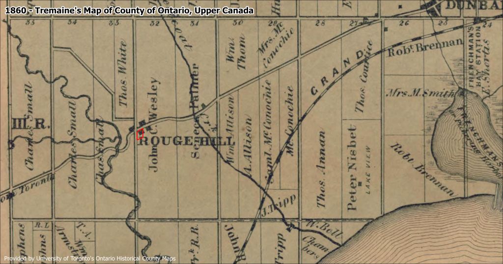
The 1860 Tremaines’ Map of County of Ontario depicts a building on the Property. It also identifies the area as Rouge Hill. Additionally, it indicates that John C. Wesley owned the entire Lot 32 and shows this building along with two others along Kingston Road on this Lot, one immediately to the east and one on the opposite side of Kingston Road. In 1860, the mortgage on the Property was discharged and it appears under the name of Sarah Wesley. That same year and throughout the 1860s, a series of transactions took place, including multiple mortgage agreements between John C. Wesley and James Black, an innkeeper. The 1860 to 1864 Tax Assessment Rolls list John C. Wesley, innkeeper, as owning the 196 acres valued at $4,800, and Michael Brooks, storekeeper and postmaster, on ½ an acre under the ownership of John C. Wesley valued at $350.74
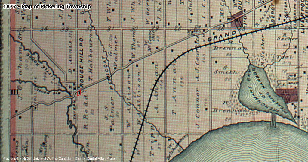
In 1874, the Property was purchased by Richard Rodd. The 1877 J.H. Beers & Co. Map of Pickering Township demonstrates a building on the Property along with two others along Kingston Road in this Lot, one immediately east and one on the opposite side of Kingston Road. The 1877 J.H. Beers & Co Map provides more detailed information including an arrow which illustrates the ownership of two parcels of land by Richard Rodd which is consistent with the 1860 Tremaines’ Map. In 1881, Robert and Naomi Moody purchased the Property.75 In 1902, they sold the Property to George Toyne for a sum of $8,000.76 That same year, George Toyne erected a silo as part of his farmstead.77 The 1913 King’s Official Route Guide notes that the Rouge Hill post office was located at the left side (south side) of Kingston Road and George Toyne had been the postmaster since 1902.78
The 1914 Topographic Map illustrates the frame building and a brick or stone building on the Property, one of which is noted as a post office, and illustrates the position of three other buildings on the north side of Kingston Road. The 1922 Topographic Map illustrates the buildings in higher fidelity including the brick or stone building on the Property. The 1936 Topographic Map illustrates the growth of the Rouge Hill community with buildings constructed along Kingston Road and along a newly extended Altona Road to the south. It does not identify the construction material of buildings. The 1943 Topographic Map illustrates the growth of the Rouge Hill community with buildings constructed along Kingston Road, along a newly extended Altona Road to the south, and the construction of Highway 401 further south. It does not identify the construction material of buildings. In 1944, George’s wife, Helen sold the one-acre Property to John and Alcona Alderice for a sum of $1,000.79
The 1946 Aerial Photograph demonstrates two buildings on the Property including the farmhouse structure with an addition surrounded by a row of trees along the property line along Kingston Road and Altona Road. The 1954 Aerial Photograph demonstrates the same buildings in higher fidelity with evidence of gardens and rows of trees visible. Kingston Road appears to have been widened and Highway 401 appears at the south of the Property. The 1962 Topographic Map illustrates the building on the Property. It does not identify the construction material of buildings.
In 1968, the Property was sold to Manfred Pfeiffer and Delmar Page. The 1969 Aerial Photograph demonstrates the same buildings in higher fidelity with evidence of gardens and rows of trees visible. Kingston Road appears to have been widened and Highway 401 appears at the south of the Property. In 1971, it was conveyed to Ruth Smith (trustee), and then shortly after, Ernest A.J. Salmon purchased the Property.80 The 1974 Topographic Map illustrates the building on the Property and the severing of Altona Road by the expansion of Highway 401. It does not identify the construction material of buildings. In 2016, the Property was purchased by the current owners.81
In 2020, the Property was one of four properties evaluated by Branch Architecture as part of the Kingston Road Study: Cultural Heritage Evaluation Report.
Known Persons of Historical Interest Associated with the Property
William Holmes (1762-1834)
William Holmes was born in Stewartstown, Northern Ireland to parents William (1730-1789) and Martha (née Stewart) (1732-1805). In 1789, he married his first wife, Mary Anne (née Jacobs) (1765-1803) in Quebec City and they had eight children.85 He was a doctor and military surgeon in Upper Canada. From 1790 to 1791 he was stationed in Newark (now Niagara-on-the- Lake). In 1792, with plans to settle in Upper Canada, William accepted a grant for 1,200 acres in Pickering Township and purchased additional land. However, in 1796 his regiment, the 5th Regiment of Foot, was relocated to Lower Canada, and Holmes’ family re-settled in Quebec City where he worked as a senior medical officer. William also established himself as in private medical practice working at both Hotel-Dieu and Hospital General.
In 1807, after the death of his first wife Mary Ann four years prior, he married his second wife, Margaret (née MacNaider) (1764-1838) in Quebec City and they had one daughter. He maintained an active medical career including the following positions: President of the Quebec examiners (1813); member of the Vaccine Board (1817); Justice of the Peace (1821); and, Commissioner for the relief of the insane and foundlings (1816). In the 1820s, Holmes retired from practice, delegating his responsibilities to younger doctors and staff. William became a keen farmer and owned well-kept properties along Chemin Sainte-Foy. In addition to his rural holdings, he owned and leased out several townhouses in Quebec City. In 1834, he passed away in Quebec City and was buried at the Cimetière Anglican Saint-Matthew.86
Thomas Dehart (1794-1850)
Thomas Dehart was born in New York to the parents of Captain Daniel Dehart (1760-1842) and Elizabeth Dehart (née Mersereau) (1760-1851). Originally from Staten Island, New York, the family settled in Whitby Township after the American Revolution.87 Thomas served in the 3rd Regiment of the York Militia under Captain Heward’s 2nd Flank Company during the War of 1812 but deserted. Afterwards, he worked as a farmer. The 1822 Census of Whitby Township notes that he lived with eight family members.88 Around 1824, he married Rebecca Dehart (née McCauslin) (1805-1860) and had four children including Lathrop (1824-1864), Charles (1826 ), William (1828-1917), and Juliet (1836-Unknown).89 In the 1836 Walton’s Directory he is listed as living in Whitby on Broken Front, Lot 35 with siblings Daniel, Nicholas, and Jacob owning adjacent properties.90 Around 1836, he moved to Hancock County, Illinois and continued farming there. In 1850, he passed away in California.91
John M. Wesley (1810-1843)
John M. Wesley was born in England.92 The 1837 Walton’s City of Toronto and Home District Directory and the 1843 Toronto Directory and Street Guide notes that for several years John Wesley was the proprietor of the Neptune Inn.93 The 1838 deed between Thomas Dehart and John Welsey notes Welsey’s occupation as an innkeeper and his residence at the time as being in Toronto. According to the 1842 Census, John was living in Toronto and working as the proprietor of the Neptune Inn.94 He married Elizabeth (1802-1838), and they had two children, Emily (1837-1837) and John C. (1838-1920). Elizabeth passed away during childbirth and they were both buried in the Toronto General Burying Ground cemetery.95
John C. Wesley (1838-1920)
John C. Wesley was born in Toronto to John Welsey and Elizabeth Wesley. In 1860, he married Elmira Wesley (née Keeler) (1841-1884) and had two daughters, Clara (1863-1931) and Mary (1865-1952). According to the 1861 Census, his family was living on the Property in a two-storey frame house, and he worked as a farmer. The other extended family members living in the house included Jane (1842) and Fanny (1843).96 John C. Wesley owned the Property for several decades and registered multiple mortgages on Property throughout the 1860s. In 1865, he worked as a postmaster at the Rouge Hill post office.97 According to the 1871 Census and the 1881 Census, he had moved to Whitby and worked in a soda water factory.98 In 1884, his wife Elmira passed away. In 1887, he married his second wife, Elmina (née Conklin) (1842-1923) in Port Hope. In 1898, he moved to Oakland, California, becoming a US citizen and running a bookstore.99 In 1920, he passed away in San Francisco, California.
George Toyne (1856-1936)
George Toyne was born in Friskney, Lincolnshire, England to parents George Toyne (1827-1897) and Elizabeth Toyne (née Linton) (1831-1906). In 1879, he married Sarah Foston, and they had four children including George Edward (1880-1943), Walter (1883), Harry (1885), and Nellie (1896-1988). The family immigrated from England to Canada in 1888, settling in Guelph for three years.100 Between 1902 and 1915, he worked as the postmaster for the Rouge Hill post office.101 In 1913, he served as a poundkeeper for the Township.102 During the early 1900s, the building on the Property was used as a polling station for various local By-laws (with the description in the Pickering News given solely as George Toyne’s House, Rouge Hill).103
According to the 1921 Census, the Toyne family lived on the Property and the building contained seven rooms.104 The 1931 Census demonstrates that the building on the Property was valued at $800, was constructed out of wood and had nine rooms, which indicates that a former rear addition may have been constructed between those years.105 A local road in the Rouge Hill community, Toynevale Road, was given its name due to the association with George Toyne.106
Historical Maps
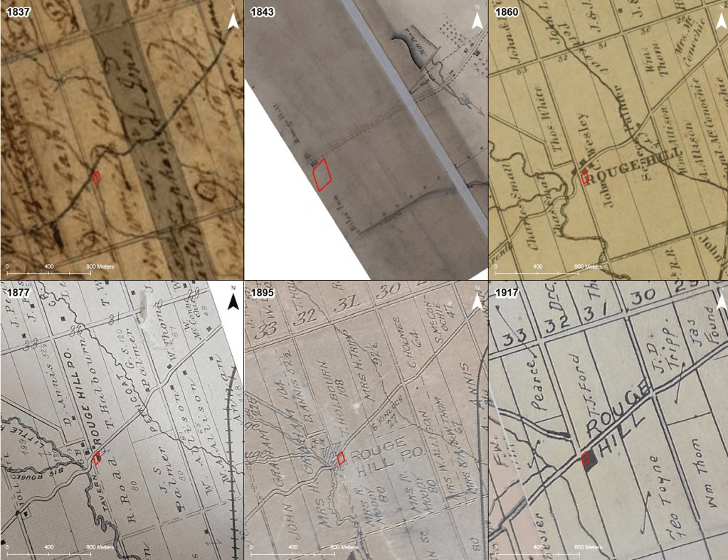
1. Archives of Ontario, “Pickering Township 1837.
2. Library and Archives Canada, “Plan and Section of the Kingston Road from the Rouge Hill to the Eastern Boundary of the ownship of Whitby 1843.
3. Shier, J., “Tremaine’s Map of the Couty of Ontario, Upper Canada, 1860
4. J.H. Beers & Co., “Map of Pickeroing Township”, In: J.H. Beers & Co., “Illustrated Historical Atlas of the County of Ontario Ont.”, 1877.
5. Charles E. Goad, “Map of the Township of Pickering, Ontario County”, scale 60 chains to 1 inch, Toronto, ON: Charles E. Goad, 1895.
6. A.E. Guidal, “Guidal Landowners’ Map of Pickering Township, Ontario County, Province of Ontario”, Map and Advertising Co. Limited, 1917.
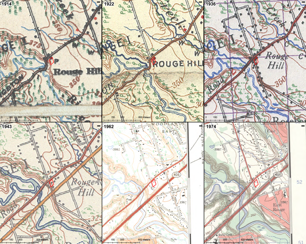
1. Department of Militia and Defence, Survey Division, “Ontaio, Markham Sheet”, 1914.
2. Department of Militia and Defence, “Quebec, Markham Sheet”, 1922.
3. Department of National Defence, Geographical Section, General Staff, “Markham, Ontario”, 1936.
4. Department of National Defence, Geographical Section, General Staff, “Markham, Ontario”, 1936.
5. Army Survey Establishment, R.C.E., “Highland Creek, Ontario”, 1962.
6. Department of Energy, Mines, and Resources, Surveys and Mapping Branch, “Highland Creek, Ontario”, 1974
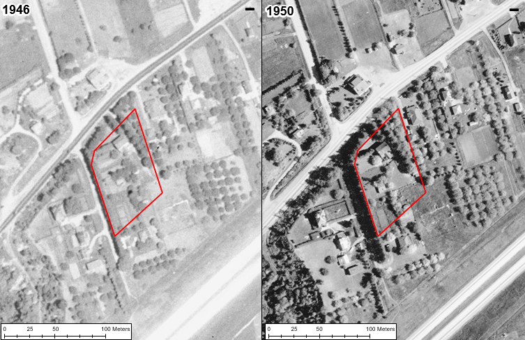
1. National Air Photo Library, “A10118-25”, scale 1:20,000, roll A10118 photo 25, 1946.
2. National Air Photo Library, “A12499-3”, scale 1:10,000, roll A12499 line 6W photo 3, 1950.
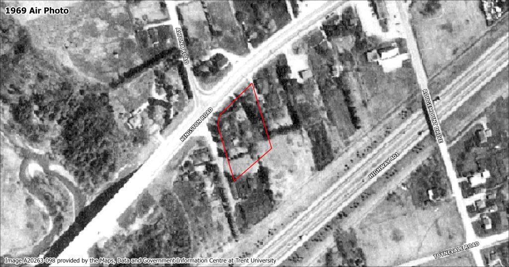
1. National Air Photo Library, “A20263-098”, 1969.
Building Description & Site Photos
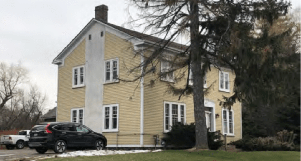
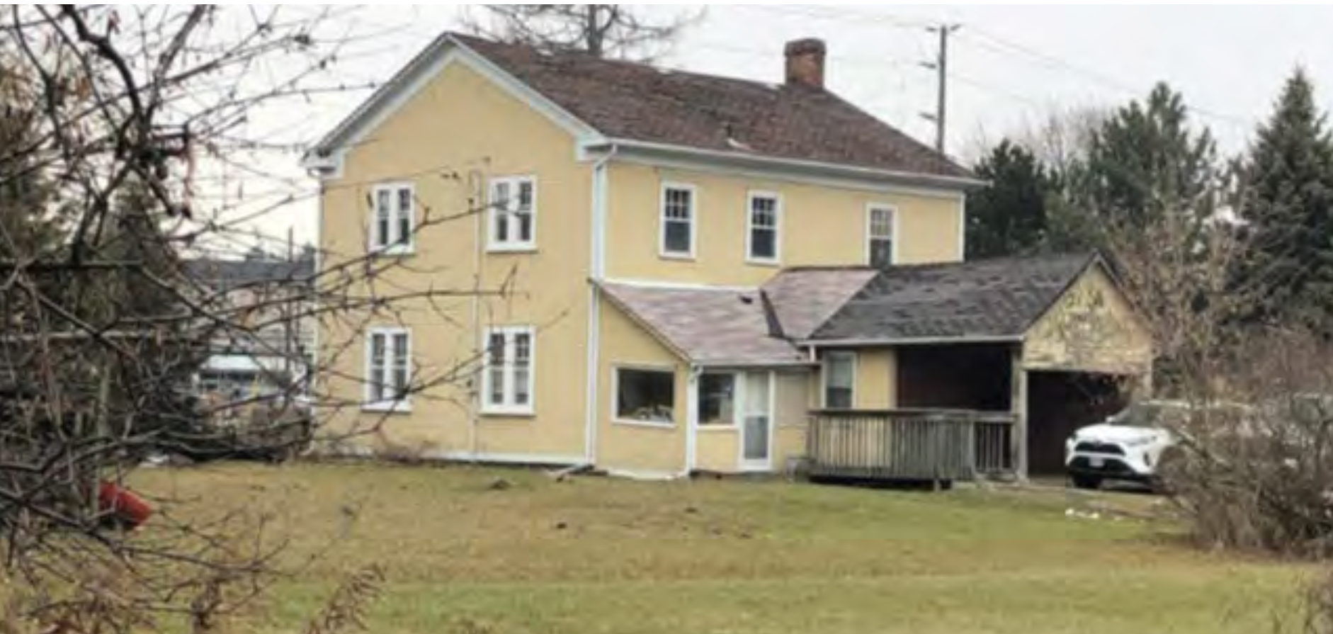
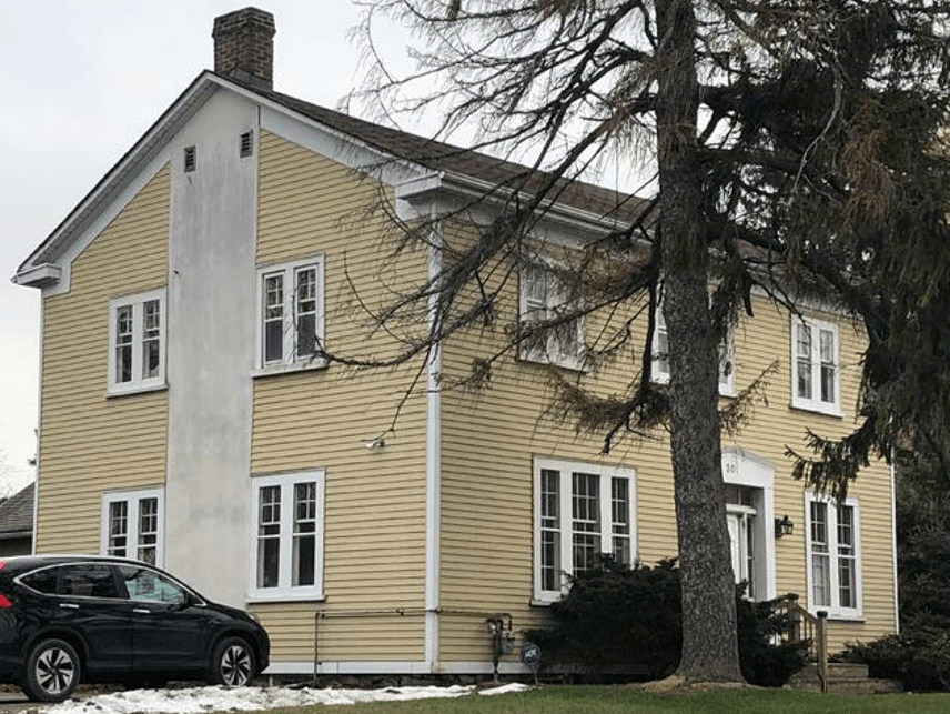
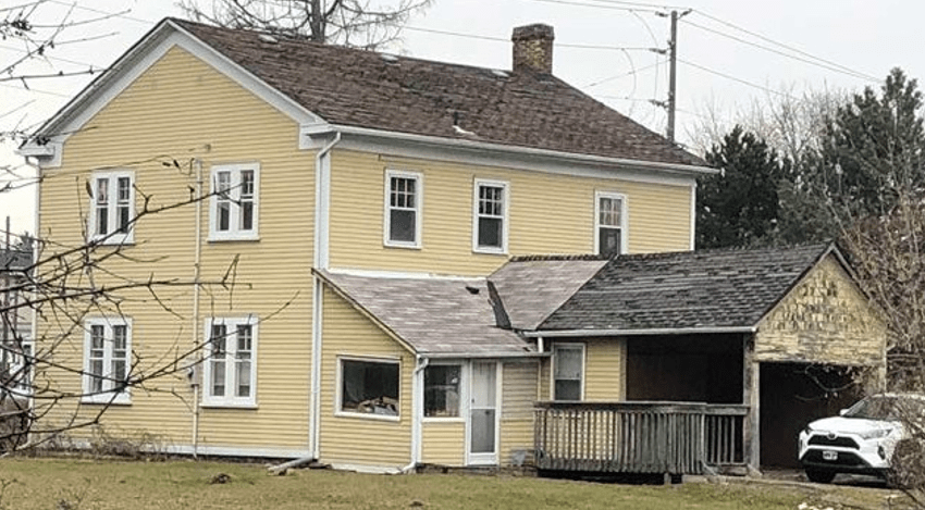
The building at 301 Kingston Road was an altered example of a mid-19th century Georgian house in Pickering.
The Georgian architectural style was brought to Upper Canada (present-day Ontario) by United Empire Loyalists relocating from the United States after the American Revolution. The style was cumulative of architectural fashion in Britain during the reign of the first three King Georges of England (1750 – 1820). Georgian architecture in Britain and in Canada was a modification of the Renaissance style adapted throughout Europe during the eighteenth century. It was a variation on the Palladian style which was known for balanced façades, muted ornament, and minimal detailing. Simplicity, symmetry, and solidity were the elements to be strived for.116
A 2020 report by Branch Architecture provided the following description and images of the house:
This style dates to 1750-1850. Based on the English Palladian and Georgian styles, this style arrived in Upper Canada first with the Common features of this building style include: a box-like massing up to 3 storeys in height; symmetrical elevations and classical proportions often displaying a balanced arrangement of windows and doors with flat or splayed window arches; simple designs with limited classical detailing; medium to high pitch gable roofs with half floors in attics and windows on gable ends; chimneys flanking gable end walls; either timber construction with clapboard siding or solid plain brick buildings; vertical sash windows with wood or stone sills; and, a central entrance door with a transom light and side lights.
The following is a description of the building with observations:
- The roof had a medium pitch gable roof profile. The roof was covered in asphalt shingle and the rain gear is painted metal. The eaves appear to have been altered with a perforated metal soffit and painted metal over cladding at the fascia, bedmold, frieze and gable-end returns. There was a single red brick chimney at the east wall.United Empire Loyalists and later with British immigrants. Georgian buildings were known for balanced façades, restrained ornamentation, and minimal detailing. It was employed by Upper Canadian settlers desiring, “a sturdy house that reflected his simple dignity”.8
- The house is a two-storey building with a gable roof. It is located on the south side of Kingston Road and overlooks Kingston Road from a small rise. At the rear of the residence are several one-storey additions.
- The front (north-facing) facade displays a balanced (though not symmetrical) arrangement of openings. On the ground floor there is a centrally placed front door flanked by window openings. On the second floor are three evenly placed window openings; they do not align with the openings below.
- The side (east and west) elevations display a symmetrical arrangement of window openings. On the east elevation there is a vertical strip between the windows; this is likely an alteration related to the chimney.
- The building has a stone foundation laid in a random pattern.
- The exterior walls are clad in horizontal pre-painted aluminum siding with a edge board detail at the base of the wall, corners and eaves. Given the depth of wall extending out from the stone foundation, it appeared that the original siding may be concealed under the existing.
- The front entrance opening is framed by a pedimented lintel and side panels. These elements have been covered in painted metal. In front of the entrance is a poured concrete step with a modern wood railing at the east side.
- The front entrance doorway was composed of a six-panel wood door flanked by wood columns, inset sidelights (2 lights over a base panel) and an inset four-light transom. The framing elements (door frame and stiles) and the base panels at the side- lights were overclad in painted metal.
- The window openings were rectangular with a thin sill and wide frames at the top, sides and mullions. There was a mix of window arrangements and patterns. On the ground floor there is: a grouping of three windows consisting of a 6-over-12 sash flanked by 4-over-6 sash windows; pairs of 4-over-6 sash windows; and, pairs of 4- over-1 sash windows. At the second floor there are 4-over-1 sash windows in pairs and threes and, at the rear elevation, 6-over-1 sash windows.

Commemoration
To commemorate the history of the building that once stood at 301 Kingston Road, the following initiatives were undertaken:
Website: A website, www.301kingston.ca, was created to allow the public easy access to the rich history associated with the property.
Bench: Timbers that were free of rot and mainly intact were carefully selected and preserved during the demolition process. A seating bench was created with these timbers and placed in a temporary location on the property. The bench will be given a permanent location once the property is developed.
Plaque: A bronze relief plaque was commissioned to depict what the building once looked like. A QR Code is provided for easy access to the website.
A few simple words:
301 Kingston Road
The Crown Patents for Lot 32, Concession 3 Broken Front was granted to prominent military surgeon William Holmes in 1798. Although Holmes never settled here, he was granted –and purchased –more than 1200 acres of land in Pickering Township. It was here that the community of Rouge Hill developed along Kingston Road, overlooking the Rouge River Valley.
In this location once stood the two-storey, wood frame Georgian residence of farmer John Charles Wesley; who farmed a 195-acre parcel of land stretching as far north as Sheppard Avenue. The house was constructed in the mid-19th century and sat in this prominent location at the corner of Kingston Road and Altona Road.
Citations
20 City of Pickering, “Council Meeting, November 27”, 27 November 2023, accessed 8 January 2024, https://www.viddler.com/v/18753fba?secret=57115818
21 Christopher Ellis and D. Brian Deller, “Paleo-Indians”, in The Archaeology of Southern Ontario to A.D. 1650, ed. Christopher Ellis and Neal Ferris, London, ON: Ontario Archaeological Society, London Chapter, 1990, 37.
22 Toronto Region Conservation Authority, “Chapter 3: First Nations”, in Greening Our Watersheds: Revitalization Strategies for Etobicoke and Mimico Creeks, prepared by the Toronto Region Conservation Authority, 2001, http://www.trca.on.ca/dotAsset/37523.pdf
23 Toronto Region Conservation Authority, “Chapter 3: First Nations”, 2001.
24 Toronto Region Conservation Authority, “Chapter 3: First Nations”, 2001. 25 Toronto Region Conservation Authority, “Chapter 3: First Nations”, 2001. 26 Toronto Region Conservation Authority, “Chapter 3: First Nations”, 2001. 27 Toronto Region Conservation Authority, “Chapter 3: First Nations”, 2001.
28 Toronto Region Conservation Authority, “Chapter 3: First Nations”, 2001; Haudenosaunee Confederacy, “Who Are We”, Haudenosaunee Confederacy, 2020, https://www.haudenosauneeconfederacy.com/who-we-are/
29 Parks Canada, “Bead Hill National Historic Site of Canada”, Directory of Federal Heritage Designations, accessed 18 January 2024, https://www.pc.gc.ca/apps/dfhd/page_nhs_eng.aspx?id=531
30 Mississaugas of the Credit First Nation, “The History of the Mississaugas of the New Credit First
Nation,” Mississaugas of the New Credit First Nation, 2018, http://mncfn.ca/wp-content/uploads/2018/04/The- History-of-MNCFN-FINAL.pdf
31 Mississaugas of the Credit First Nation, “History”, 3-4. 32 Mississaugas of the Credit First Nation, “History”, 3-4. 33 Mississaugas of the Credit First Nation, “History”, 3-4.
34 Toronto Region Conservation Authority, “Archaeology Opens a Window on the History of Indigenous Peoples in the GTA,” News, 2018, https://trca.ca/news/archaeology-indigenous-peoples-gta/
35 Melba E. McKay, Pickering Women’s Institute, 1957, 11.
36 Government of Ontario, “Johnson-Butler Purchase”, 13 January 2022, accessed 18 January 2024, https://www.ontario.ca/page/map-ontario-treaties-and-reserves#t4
37 Williams Treaties First Nations, “Gunshot Treaty,” Pre-Confederation Treaties, n.d.
38 Robert J. Surtees, “Treaty Research Report: The Williams Treaties”, Treaties and Historical Research Centre, Indian and Northern Affairs Canada, 1986.
39 Robert J. Surtees, “Treaty Research Report: The Williams Treaties”, Treaties and Historical Research Centre, Indian and Northern Affairs Canada, 1986, 19.
40 Robert J. Surtees, “Treaty Research Report: The Williams Treaties”, Treaties and Historical Research Centre, Indian and Northern Affairs Canada, 1986, 20.
41 Toronto Public Library, “Local History & Genealogy, Selections and Full PDFs of “The Jesuit Relations”: Sainte- Marie among the Hurons and Beyond,” accessed 18 January 2024, https://torontopubliclibrary.typepad.com/local- history-genealogy/2020/01/sainte-marie-among-the-hurons-selections-from-the-jesuit-relations-and-allied- documents.html
42 Peel Art Gallery, Museum, and Archives [PAMA], “About Peel,” 2022, accessed 19 January 2024, https://peelarchivesblog.com/about-peel/
43 Williams Treaties First Nations, Map of William Treaties and Pre-Confederation Treaties, https://williamstreatiesfirstnations.ca/maps-of-our-treaties/.
44 J.E. Farewell, Ontario County: A Short Sketch of Its Settlement, Physical Features, and Resources with Brief Historical Notes, Whitby, ON: Gazette-Chronicle Press, 1907, 11-13; William R. Wood, Past Years in Pickering: Sketches of the History of the Community, Toronto, ON: William Briggs, 1911, 16-18.
45 W.C. Murkar, “Early Settlers in Pickering”, Pickering News, 29 June 1961.
46 William H. Smith, Smith’s Canadian Gazetteer: Comprising Statistical and General Information Respecting All Parts of the Upper Province, or Canada West, Toronto, C.W.: H. & W. Rowsell, 1846, 146.
47 William H. Smith, Smith’s Canadian Gazetteer: Comprising Statistical and General Information Respecting All Parts of the Upper Province, or Canada West, Toronto, C.W.: H. & W. Rowsell, 1846, 146.
48 William H. Smith, Canada: Past, Present and Future, Being A Historical, Geographical, Geological and Statistical Account of Canada West, Vol. II, Toronto, C.W.: Thomas Maclear, 1851, 21.
49 R.A. Murison, The Village of Pickering 1800-1970, Pickering, ON: The Corporation of the Village of Pickering, 1970, 3.
50 William R. Wood, Past Years in Pickering: Sketches of the History of the Community, Toronto, ON: William Briggs, 1911, 163-164.
51 City of Toronto, “Kingston Road– Wards 36, 43, 44–Kingston Road Initiative– Action Report”, 10 March 2009, accessed 26 January 2024, https://www.toronto.ca/legdocs/mmis/2009/sc/bgrd/backgroundfile-19593.pdf
52 City of Toronto, “Kingston Road– Wards 36, 43, 44–Kingston Road Initiative– Action Report”, 10 March 2009, accessed 26 January 2024, https://www.toronto.ca/legdocs/mmis/2009/sc/bgrd/backgroundfile-19593.pdf
53 William H. Smith, Canada: Past, Present and Future, Being A Historical, Geographical, Geological and Statistical Account of Canada West, Vol. II, Toronto, C.W.: Thomas Maclear, 1851, 21.
54 William H. Smith, Canada: Past, Present and Future, Being A Historical, Geographical, Geological and Statistical Account of Canada West, Vol. II, Toronto, C.W.: Thomas Maclear, 1851, 21.
55 Max Rosenthal, “Early Post Offices in Pickering Township”, Pickering Historical Society, 4 June 1965, accessed 29 November 2023, 7; William R. Wood, Past Years in Pickering: Sketches of the History of the Community, Toronto, ON: William Briggs, 1911, 161.
56 The British American guide-book: being a condensed gazetteer, directory and guide, to Canada, the Western States, and principal cities on the Seaboard, New York, NY: H. Bailliere, 1859, 67.
57 W.A. McKay, The Pickering Story, Pickering, ON: The Township of Pickering Historical Society, 1961, 120.
58 Tweedsmuir History – Pickering Women’s Institute, Years of Growth, 1957, 85
59 TheKing’sHighway.ca, “Photographic History of King’s Highway 2”, accessed 15 January 2024, https://www.thekingshighway.ca/PHOTOS-3/hwy2-143_lg.jpg
60 TheKing’sHighway.ca, “Photographic History of King’s Highway 2”, accessed 15 January 2024.
61 Facebook, “Scarborough, Looking Back..”. 5 April 2010, accessed 15 January 2024, https://www.facebook.com/photo/?fbid=10150179564900273&set=a.487003990272
63 Land Registry Ontario, Durham (LRO 40), Inst. Crown Patent; Barbara Tunis, “Holmes, William (d.1834),” Dictionary of Canadian Biography, vol. 6., University of Toronto/Université Laval, 2003, accessed 28 November 2023, http://www.biographi.ca/en/bio/holmes_william_1834_6E.html
64 Branch Architecture, “Kingston Road Study Cultural Heritage Evaluation Report,” 2020, 27.
65 Barbara Tunis, “Holmes, William (d.1834),” Dictionary of Canadian Biography, 2003.
66 Land Registry Ontario, Durham (LRO 40), 1838, Inst. 16364.
67 Land Registry Ontario, Durham (LRO 40), 1838, Inst. 16364. It is unclear when Thomas Dehart came into possession of the property.
68 Land Registry Ontario, Durham (LRO 40), 1843, Inst. 21307.
69 Land Registry Ontario, Durham (LRO 40), 1843, Inst. 21394.
70 Brown’s Toronto City and Home District Directory, 1846-7, Toronto, C.W: George Brown, 1846, 65.
71 Tax Assessment Roll for the Township of Pickering, 1853.
72 Tax Assessment Roll for the Township of Pickering, 1852, Lines 84-85; Tax Assessment Roll for the Township of Pickering, 1858, Line 78.
73 Tax Assessment Roll for the Township of Pickering, 1859, Lines 83-84.
74 Tax Assessment Roll for the Township of Pickering, 1861, Lines 83-84.
75 Land Registry Ontario, Durham (LRO 40), 1881, Inst. 5572.
76 Land Registry Ontario, Durham (LRO 40), 1902, Inst. 10046.
77 “Rouge Hill”, The Pickering News, 31 October 1902, 1.
78 Sidney J. King, King’s Official Route Guide, Section 7: King’s Routes of Michigan, Province of Ontario, Can., and New York, Chicago, IL: Sidney J. King, 1913, 248.
79 Land Registry Ontario, Durham (LRO 40), 1944, Inst. 24411.
80 Land Registry Ontario, Durham (LRO 40), 1971, Inst. CO205500.
81 Land Registry Ontario, Durham (LRO 40), 2016, Inst. DR1500267.
82 Branch Architecture, “Kingston Road Study Cultural Heritage Evaluation Report,” 2020.
83 Branch Architecture, “Kingston Road Study Cultural Heritage Evaluation Report,” 2020.
84 Branch Architecture, “Kingston Road Study Cultural Heritage Evaluation Report,” 2020.
85 Ancestry.ca, “Dr. William Holmes (1762-1834)”, user Peter Charles Smith, n.d., accessed 24 January 2024, https://www.ancestry.ca/family-tree/person/tree/167269431/person/152205905233/facts
86 Barbara Tunis, “Holmes, William (d.1834),” Dictionary of Canadian Biography, 2003; Branch Architecture, “Kingston Road Study Cultural Heritage Evaluation Report,” 2020.
87 Ancestry.ca, “Thomas Dehart (1794-1850)”, accessed 29 November 2023, https://www.ancestry.ca/family- tree/person/tree/52426656/person/262471322065/gallery?galleryPage=1
88 “1822 Census of Whitby Township”, Oshawa Vindicator, 18 May 1864, 2, accessed 29 November 2023, https://0901.nccdn.net/4_2/000/000/046/6ea/1822-census-of-whitby-township.pdf
89 1850 United States Federal Census, 1850, 352, accessed 29 November 2023, https://www.ancestry.ca/discoveryui-content/view/16245286:8054?ssrc=pt&tid=71505275&pid=212213418375
90 Thomas E. Kaiser, Historic Sketches of Oshawa, Oshawa, ON: Reforming Printing & Publishing Co., 1921, 208. 91 Ancestry.ca, “Thomas Dehart (1794-1850)”, accessed 29 November 2023, https://www.ancestry.ca/family- tree/person/tree/52426656/person/262471322065/gallery?galleryPage=1
92 Find-a-Grave, “John M. Wesley (1810-1843)”, accessed 18 January 2024, https://www.findagrave.com/memorial/249735652/john-m-wesley
93 The City of Toronto and the Home District commercial directory and register with almanack and calendar for 1837, Toronto, U.C: T. Dalton & W.J. Coates, 1837, 33; Francis Lewis, The Toronto Directory and Street Guide for 1843-4, Toronto, C.W., H. & W. Rowsell, 1843, 78.
94 Library and Archives Canada, 1842 Census of Canada West, accession no. 47162032, 1842. 95 FamilySearch, “York. Burial Registers 1850-1959, Film 004455459, https://www.familysearch.org/ark:/61903/3:1:S3HT-DRKS-W1H?view=index&action=view
96 Library and Archives Canada, 1861 Census of Canada West, 1861, 100, Line 32.
97 Library and Archives Canada, “Rouge Hill”, Archives / Post Offices and Postmasters, accession no. RG3-D-3, accessed 29 November 2023, http://central.bac-lac.gc.ca/.redirect?app=posoffposmas&id=9769&lang=eng
98 Library and Archives Canada, 1871 Census of Canada, 1871, 28, Line 14; Library and Archives Canada, 1881 Census of Canada, Enumeration District No. 132 Ontario South, Sub-district Whitby Town, 1881, 1, Line 23.
99 Department of Commerce and Labor, Thirteenth Census of the United States, Enumeration District No. 122, Oakland City, 1910, 18, Line 2.
100 Ancestry.ca, “George Toyne (1854-1936)”, accessed 29 November 2023, https://www.ancestry.ca/family- tree/person/tree/111047899/person/330086652521/facts
101 Library and Archives Canada, “Rouge Hill”, Archives / Post Offices and Postmasters, accession no. RG3-D-3, accessed 29 November 2023, http://central.bac-lac.gc.ca/.redirect?app=posoffposmas&id=9769&lang=eng
102 “Pickering Council”, The Pickering News, 13 January 1913, 3.
103 “By-law No. 871”, The Pickering News, 1 January 1909, 4; “By-law No. 1159”, The Pickering News, 30 December 1921, 3.
104 Library and Archives Canada, Sixth Census of Canada, 1921, Enumeration District No. 3 Pickering, 1921, 1, Line 26.
105 Library and Archives Canada, Seventh Census of Canada, 1931, Enumeration District No. 3 Pickering Township, 1931, 1, Line 17.
106 “Neighbours Remember When”, The 1ST Rouge Hill Girl Guide Company, 1984, accessed 29 November 2023, 14, https://corporate.pickering.ca/PLHCWebLink/0/edoc/171193/498.pdf
107 Parks Canada, “Rouge National Urban Park”, 2021, accessed 11 December 2023, https://www.pc.gc.ca/en/pn- np/on/rouge
108 Clarke Engineering, “Re: 301 Kingston Road, Pickering, Ontario”, Draft Structural Engineering Report, 19 January 2024, 6.
109 Clarke Engineering, “Re: 301 Kingston Road, Pickering, Ontario”, Draft Structural Engineering Report, 19 January 2024, 6.
112 Clarke Engineering, “Re: 301 Kingston Road, Pickering, Ontario”, Draft Structural Engineering Report, 19 January 2024, 2.
113 Clarke Engineering, “Re: 301 Kingston Road, Pickering, Ontario”, Draft Structural Engineering Report, 19 January 2024, 2.
114 Clarke Engineering, “Re: 301 Kingston Road, Pickering, Ontario”, Draft Structural Engineering Report, 19 January 2024, 4.
115 Clarke Engineering, “Re: 301 Kingston Road, Pickering, Ontario”, Draft Structural Engineering Report, 19 January 2024, 2.
116 Shannon Kyles, “Georgian (1750-1850)”, OntarioArchitecture, n.d., accessed 5 December 2023, http://www.ontarioarchitecture.com/georgian.htm
- The Pickering Story, p. 21.
- The Crown provided Loyalists with 200 acres and military grants of up to 5,000 acres for free. Settlers paid the Crown for 200 acre parcels.
8 Ontario Architecture, www.ontarioarchitecture.com.
Websites
- Ancentry. www.ancestry.ca
- Biographical Dictionary of Architects in Canada 1800-1950, www.dictionaryofarchitectsin- canada.org.
- Davidson-Langley Incorporated Architects. www.dlia.ca.
- Library and Archives of Canada. www.bac-lac.gc.ca
- Ontario Architecture, www.ontarioarchitecture.com.
- Ontario Archives. www.archives.gov.on.ca
- Ontario Land Registry Access. www.onland.ca
- Pickering Archives. www.coporate.pickering.ca
- St. Paul’s on-the-Hill Anglican Church. www.stpaulonthehill.com
